Iyeltak:1798 Cassini Map of Alaska and the Bering Strait - Geographicus - Alaska-cassini-1798.jpg
Lum ke bata abdiwira : 800 × 579 px. Ar goraks: 320 × 232 px | 640 × 464 px | 1024 × 742 px | 1280 × 927 px | 2560 × 1854 px | 4000 × 2897 px.
Xantaf iyeltak (4000 × 2897 pixel, iyeltakaldo : 3,09 Mio, MIME ord : image/jpeg)
| Le Coste Nord Ovest Dell' America e Nord Est Dell' Asia Delineate sulle ultime Osservazioni del Cp. Cook. | ||||||
|---|---|---|---|---|---|---|
| Artiste | ||||||
| Titre |
Le Coste Nord Ovest Dell' America e Nord Est Dell' Asia Delineate sulle ultime Osservazioni del Cp. Cook. |
|||||
| Pimtara |
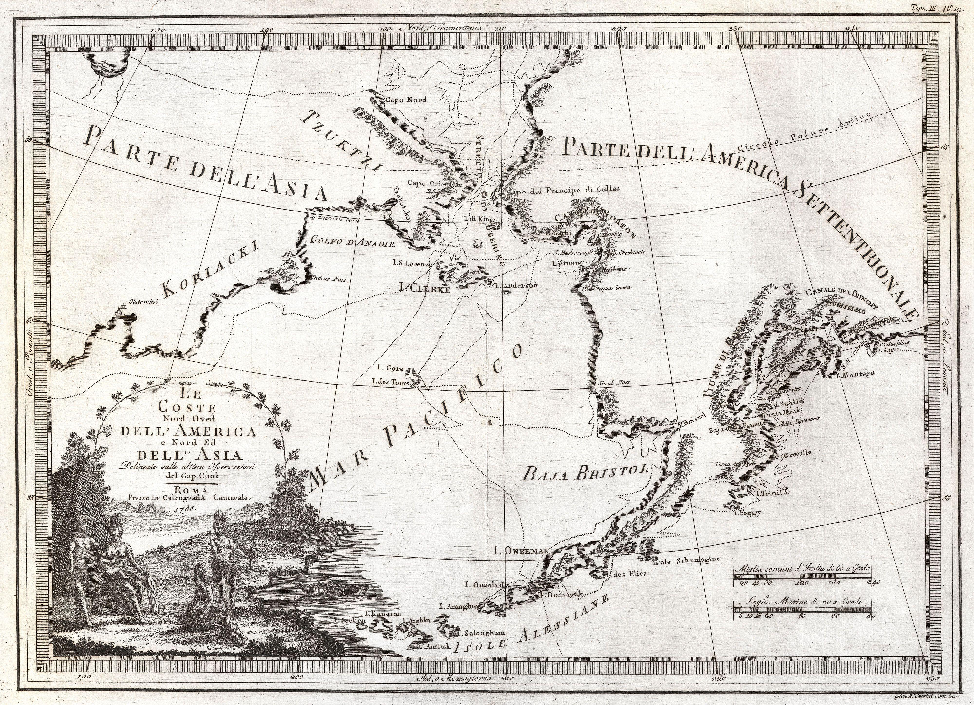
English: An extraordinarily fine example of Cassini's 1798 map of Alaska, the Bering Strait, and Siberia. Cassini issued this map in his 1798 atlas to illustrate the discoveries made by James Cook. Cook was the first to accurately chart the Alaskan coastline and provide a detailed mapping of the Aleutian Islands. Cook's zigzagging route is shown as he skirts the Aleutian Islands, passes through the Bering Strait into the Arctic Ocean, and then turns back to sail south along the Siberian Coast. Here the Aleutians are collectively identified as Isole Alessiane, though many of the original islands are clearly given indigenous names. A large decorative cartouche in the lower left depicts four American Indians and a baby. This is perhaps the most beautiful of the many maps designed to illustrate Cook's voyages. |
|||||
| Evla | 1798 (dated) | |||||
| Dimensions | hauteur : 14,5 pouces (36,8 см) ; largeur : 20 pouces (50,8 см) | |||||
| Numéro d’inventaire |
liens Geographicus : Alaska-cassini-1798 |
|||||
| Source / photographe |
Cassini, Giovanni Maria, Nuovo Atlante Geografico Universale Delineato Sulle Ultime Osservazioni, V. 3, Rome: Calcogrfia camerale, 1798.
|
|||||
| Novera (Va bata ewava gin faver) |
|
|||||
Iyeltakizvot
Witison va iyeltak inde in banugale awir, va evla/bartiv vulegal !!
| Evla/Bartiv | Aluk | Lumeem | Favesik | Sebuks | |
|---|---|---|---|---|---|
| ref | 24 bareaksat 2011 à 18:26 | | 4000 × 2897 (3,09 Mio) | BotMultichillT | {{subst:User:Multichill/Geographicus |link=http://www.geographicus.com/P/AntiqueMap/Alaska-cassini-1798 |product_name=1798 Cassini Map of Alaska and the Bering Strait |map_title=Le Coste Nord Ovest Dell' America e Nord Est Dell' Asia Delineate sulle ultim |
Favera va iyeltak
Valevefa 2 bugluyaxa va bat iyeltak :
Jadifa iyeltakura
Valevefi wiki va bat iyeltak malsaved :
- Favera dene sh.wikipedia.org