Iyeltak:Africa-regions.png
Me rodadin logijaf lum.
Africa-regions.png (360 × 392 pixel, iyeltakaldo : 8 kio, MIME ord : image/png)
Pimtara
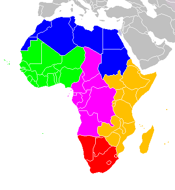
Africa: subregions as delineated by United Nations geographic classification scheme:
Sortara :
Moi, en tant que détenteur des droits d’auteur sur cette œuvre, je la publie sous les licences suivantes :

|
Permission is granted to copy, distribute and/or modify this document under the terms of the GNU Free Documentation License, Version 1.2 or any later version published by the Free Software Foundation; with no Invariant Sections, no Front-Cover Texts, and no Back-Cover Texts. A copy of the license is included in the section entitled GNU Free Documentation License. |
| Bat iyeltak wetce Creative Commons Attribution-Share Alike 3.0 Unported zo sortayar. | ||
| ||
| Ce bandeau de licence a été ajouté à ce fichier dans le cadre de la procédure de mise à jour des licences des images sous GFDL. |
Ce fichier est sous licence Creative Commons Attribution – Partage dans les Mêmes Conditions 2.5 Générique, 2.0 Générique et 1.0 Générique.
- Til nuyaf :
- Ta walzilira – ta ksudara va kobara azu walzilira azu deara
- Ta warzafa ponara – Ta zalera va grabom
- Nope valevef kredeem :
- gaara – Va folack govanzilil ise va gluyaxa godaful ise gobazel kase betara al zo skud. Laninde gonaskil voxe mekane gometiavel da gelfasik va rin ik rinafa favera vanovar.
- Milinde paká – Ede va bat valdig betal ike artazukar ike voner, pune va nekis valdig wetce mila ok milafa sorta gu bat goxolel.
Va solnarina sorta rorewal

|
Une version vectorielle de cette image existe, dans le format « SVG ». Si elle n’est pas inférieure, elle devrait être utilisée à la place de la présente version pour des affichages en plus grandes dimensions ou nécessitant une meilleure résolution.
File:Africa-regions.png → File:Africa map regions.svg
Pour plus d’informations sur les images vectorielles, consultez la page de transition de Commons vers le format SVG. Voir aussi les informations à propos de la manière dont le logiciel MediaWiki gère les images au format SVG. |
 |
Iyeltakizvot
Witison va iyeltak inde in banugale awir, va evla/bartiv vulegal !!
| Evla/Bartiv | Aluk | Lumeem | Favesik | Sebuks | |
|---|---|---|---|---|---|
| ref | 1 teveaksat 2018 à 02:02 | | 360 × 392 (8 kio) | Vesperius | Reverted to version as of 18:36, 28 May 2018 (UTC) (Most definitions of the regions include the Horn of Africa as part of East Africa, so I'm reverting this back) |
| 28 alubeaksat 2018 à 18:37 |  | 360 × 392 (10 kio) | Vesperius | Reverted to version as of 18:25, 28 May 2018 (UTC) (Messed up, the purple indicating the Horn of Africa didn't show up for me) | |
| 28 alubeaksat 2018 à 18:36 |  | 360 × 392 (8 kio) | Vesperius | Reverted to version as of 01:04, 16 May 2018 (UTC) | |
| 28 alubeaksat 2018 à 18:25 |  | 360 × 392 (10 kio) | Vesperius | Reverted to version as of 18:57, 17 March 2018 (UTC) | |
| 16 alubeaksat 2018 à 01:04 |  | 360 × 392 (8 kio) | Dwo | Reverted to version as of 08:22, 30 August 2015 (UTC) | |
| 17 bareaksat 2018 à 18:57 |  | 360 × 392 (10 kio) | Maphobbyist | Montenegro border | |
| 30 anyusteaksat 2015 à 08:22 |  | 360 × 392 (8 kio) | Wiki-Zyron | Reverted to version as of 00:23, 20 December 2012 - Reverted to the last version before someone inexplicably moved Zimbabwe to Southern Africa. Eastern Africa is the correct region - [http://unstats.un.org/unsd/methods/m49/m49regin.htm#africa] | |
| 21 balemeaksat 2015 à 05:04 |  | 360 × 392 (16 kio) | TAKASUGI Shinji | Corrected the color of Zimbabwe | |
| 18 santoleaksat 2014 à 15:16 |  | 360 × 392 (17 kio) | Hybscher | wrong colors | |
| 22 santaneaksat 2014 à 22:39 |  | 2000 × 2050 (342 kio) | Andrew J.Kurbiko | pp |
Favera va iyeltak
Valevefa bugluyaxa va bat iyeltak :
Jadifa iyeltakura
Valevefi wiki va bat iyeltak malsaved :
- Favera dene af.wikipedia.org
- Favera dene anp.wikipedia.org
- Favera dene ar.wikipedia.org
- Favera dene arz.wikipedia.org
- Favera dene azb.wikipedia.org
- Favera dene ba.wikipedia.org
- Favera dene bg.wikipedia.org
- Favera dene blk.wikipedia.org
- Favera dene bn.wikipedia.org
- Favera dene br.wikipedia.org
- Favera dene bxr.wikipedia.org
- Favera dene ca.wikipedia.org
- Favera dene cy.wikipedia.org
- Favera dene de.wikipedia.org
- Favera dene el.wikipedia.org
- Favera dene en.wikipedia.org
- Southern Africa
- Walvis Bay-Ndola-Lubumbashi Development Road
- N1 road (Gabon)
- User:R4000/Africa(Alt)
- Cairo Road
- User:ArminHammer
- User:Donbert/motherafrica
- User:Donbert/userboxes
- United Nations geoscheme
- United Nations geoscheme for Africa
- Rua Libertadores de África
- Lists of cities in Africa
- Portuguese Africans
- Sam Nujoma Street
- Cairo–Dakar Highway
- N'Djamena–Djibouti Highway
- Portal:Africa/Countries
- Portal:Africa/Countries/Map
loa favera va bat iyeltak wil !!