Iyeltak:Aras River, Turkey-Armenia-Iran Border Region.JPG

Xantaf iyeltak (4288 × 2848 pixel, iyeltakaldo : 13,14 Mio, MIME ord : image/jpeg)
Pimtara
| Pimtara |
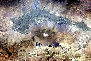
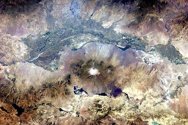
English: This astronaut photograph, taken from the International Space Station, highlights a segment of the international border between Armenia and Turkey. The Aras River separates the two countries, with Armenia to the north-north-east and Turkey to the south-south-west. Extensive green agricultural fields are common on both sides of the river (upper part of image), as well as a number of gray-to-tan urban areas including Yerevan (image top, slightly left of centre) and Artashat and Armavir in Armenia, and Iğdır in Turkey. While there have been efforts to normalize diplomatic relations between the two countries in recent years, the Armenia-Turkey border remains officially closed.
The dominant geographic feature in the region is Mt. Ararat, also known as Agri Dagi. The peak of Ararat, a large stratovolcano that last erupted in 1840 according to historical records, is located approximately 40 kilometres to the south of the Armenia-Turkey border. A lower peak to the east, known as Lesser or Little Ararat, is also volcanic in origin. Dark gray lava flows to the south of Mt. Ararat are located near the Turkish border with Iran. While this border is also closed along much of its length, official crossing points allow relatively easy travel between the two countries. The white, glacier-clad peak of Mt. Ararat is evident at image centre; dark green areas on the lower slopes indicate where vegetation cover is abundant. A large lake, Balik Golu or Fish Lake, is visible to the west (image lower left). |
| Evla | |
| Klita | NASA Earth Observatory |
| Askisik | ISS Expedition 28 crew |
| Lieu de la prise de vue | | Voir cet endroit et d’autres images sur : OpenStreetMap |
|---|
Cette image ou vidéo a été cataloguée par le Johnson Space Center de la National Aeronautics and Space Administration (NASA) des États-Unis sous Photo ID : ISS028-E-15023.Ce bandeau n’indique rien sur le statut de l’œuvre au regard du droit d'auteur. Un bandeau de droit d’auteur est requis. Voir Commons:À propos des licences pour plus d’informations. Autres langues :
|
Image acquired with a Nikon D2Xs digital camera using a 65 mm lens, and is provided by the ISS Crew Earth Observations experiment and Image Science & Analysis Laboratory, Johnson Space Center.
Sortara :
| Ce fichier provient de la NASA. Sauf exception, les documents créés par la NASA ne sont pas soumis à copyright. Pour plus d'informations, voir la politique de copyright de la NASA. | ||
 |
Attention :
|
| Annotations | This image is annotated: View the annotations at Commons |
Iyeltakizvot
Witison va iyeltak inde in banugale awir, va evla/bartiv vulegal !!
| Evla/Bartiv | Aluk | Lumeem | Favesik | Sebuks | |
|---|---|---|---|---|---|
| ref | 25 pereaksat 2011 à 18:37 | | 4288 × 2848 (13,14 Mio) | Originalwana | {{Information |Description ={{en|1=This astronaut photograph, taken from the International Space Station, highlights a segment of the international border between Armenia and Turkey. The Aras River separates the two countries, with Armenia |
Favera va iyeltak
Valevefa bugluyaxa va bat iyeltak :
Jadifa iyeltakura
Valevefi wiki va bat iyeltak malsaved :
- Favera dene af.wikipedia.org
- Favera dene ar.wikipedia.org
- Favera dene ast.wikipedia.org
- Favera dene bn.wikipedia.org
- Favera dene ca.wikipedia.org
- Favera dene en.wikipedia.org
- Favera dene es.wikipedia.org
- Favera dene fa.wikipedia.org
- Favera dene fi.wikipedia.org
- Favera dene gl.wikipedia.org
- Favera dene hsb.wikipedia.org
- Favera dene hy.wikipedia.org
- Favera dene hyw.wikipedia.org
- Favera dene it.wikipedia.org
- Favera dene ja.wikipedia.org
- Favera dene ka.wikipedia.org
- Favera dene ku.wikipedia.org
- Favera dene ml.wikipedia.org
- Favera dene pt.wikipedia.org
- Favera dene ro.wikipedia.org
- Favera dene ru.wikipedia.org
- Favera dene sk.wikipedia.org
- Favera dene sl.wikipedia.org
- Favera dene sv.wikipedia.org
- Favera dene tr.wikipedia.org
- Favera dene ur.wikipedia.org
- Favera dene uz.wikipedia.org