Iyeltak:Balearic Sea map.png
Lum ke bata abdiwira : 800 × 511 px. Ar goraks: 320 × 204 px | 640 × 409 px | 1000 × 639 px.
Xantaf iyeltak (1000 × 639 pixel, iyeltakaldo : 77 kio, MIME ord : image/png)
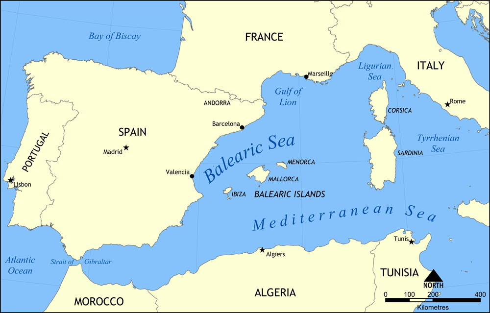
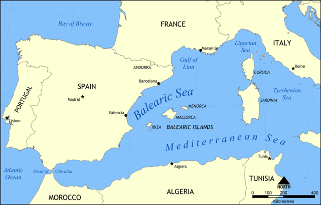
Map showing the location of the Balearic Sea, part of the Mediterranean Sea.
Created by NormanEinstein, May 26, 2006.
Moi, en tant que détenteur des droits d’auteur sur cette œuvre, je la publie sous la licence suivante :

|
Permission is granted to copy, distribute and/or modify this document under the terms of the GNU Free Documentation License, Version 1.2 or any later version published by the Free Software Foundation; with no Invariant Sections, no Front-Cover Texts, and no Back-Cover Texts. A copy of the license is included in the section entitled GNU Free Documentation License. |
| Bat iyeltak wetce Creative Commons Attribution-Share Alike 3.0 Unported zo sortayar. | ||
| ||
| Ce bandeau de licence a été ajouté à ce fichier dans le cadre de la procédure de mise à jour des licences des images sous GFDL. |
Iyeltakizvot
Witison va iyeltak inde in banugale awir, va evla/bartiv vulegal !!
| Evla/Bartiv | Aluk | Lumeem | Favesik | Sebuks | |
|---|---|---|---|---|---|
| ref | 26 alubeaksat 2006 à 15:31 | | 1000 × 639 (77 kio) | NormanEinstein | Map showing the location of the Balearic Sea, part of the Mediterranean Sea. Created by NormanEinstein, May 26, 2006. {{GFDL-self}} Category:Maps of seas |
Favera va iyeltak
Valevefa bugluyaxa va bat iyeltak :
Jadifa iyeltakura
Valevefi wiki va bat iyeltak malsaved :
- Favera dene af.wikipedia.org
- Favera dene an.wikipedia.org
- Favera dene az.wikipedia.org
- Favera dene az.wiktionary.org
- Favera dene be.wikipedia.org
- Favera dene bg.wikipedia.org
- Favera dene bn.wikipedia.org
- Favera dene bs.wikipedia.org
- Favera dene ca.wikipedia.org
- Favera dene ce.wikipedia.org
- Favera dene ckb.wikipedia.org
- Favera dene cv.wikipedia.org
- Favera dene da.wikipedia.org
- Favera dene en.wikipedia.org
- HMS Nelson (28)
- French battleship Bouvet
- Balearic Sea
- Malta convoys
- User:NormanEinstein/gallery
- French ironclad Dévastation
- French battleship Mirabeau
- French battleship Justice
- French battleship Vérité
- French battleship République
- French battleship Patrie
- French ironclad Magenta (1890)
- French battleship Charles Martel
- French battleship Brennus
- French ironclad Marceau
- French ironclad Neptune
- French cruiser Lavoisier
- French cruiser Troude
- Action of 19 February 1801
- User talk:Keith-264/sandbox5
- French cruiser Milan
- French cruiser Tage
- French cruiser Sfax
- French cruiser Forbin
- French cruiser Lalande
- French cruiser Cosmao
- French cruiser Cassard
- French cruiser Du Chayla
- French cruiser D'Iberville
- French cruiser Casabianca
- Favera dene es.wikipedia.org
loa favera va bat iyeltak wil !!