Iyeltak:Bonobo distribution.svg

Taille de cet aperçu PNG pour ce fichier SVG : 635 × 600 px. Ar goraks: 254 × 240 px | 508 × 480 px | 813 × 768 px | 1084 × 1024 px | 2169 × 2048 px | 1525 × 1440 px.
Xantaf iyeltak (SVG iyeltak, prekson 1525 × 1440 pixels, iyeltakaldo : 577 kio)
Pimtara
| Pimtara |
Map: Lambert azimutal equal-area projection, WGS84 datum, standard meridian: 15°E, standard parallel: 0° Scale: 1:15,000,000 |
| Evla | (UTC) |
| Klita | |
| Askisik |
|
Sortara :
Bat iyeltak wetce Creative Commons Attribution-Share Alike 3.0 Unported zo sortayar.
- Til nuyaf :
- Ta walzilira – ta ksudara va kobara azu walzilira azu deara
- Ta warzafa ponara – Ta zalera va grabom
- Nope valevef kredeem :
- gaara – Va folack govanzilil ise va gluyaxa godaful ise gobazel kase betara al zo skud. Laninde gonaskil voxe mekane gometiavel da gelfasik va rin ik rinafa favera vanovar.
- Milinde paká – Ede va bat valdig betal ike artazukar ike voner, pune va nekis valdig wetce mila ok milafa sorta gu bat goxolel.
Journal des téléversements d’origine
This image is a derivative work of the following images:
- File:Africa_map_blank.svg licensed with Cc-by-sa-2.5,2.0,1.0, Cc-by-sa-3.0-migrated, GFDL
- 2011-07-14T19:50:24Z Sting 1525x1440 (698781 Bytes) Sudan/South Sudan 2011-07 border update
- 2009-01-10T20:36:44Z Sting 1525x1440 (710059 Bytes) Detail correction
- 2008-06-27T03:34:58Z Sting 1525x1440 (711453 Bytes) Completely new drawing with known projection
- 2006-05-31T15:28:42Z Sting 1390x1295 (571519 Bytes) Enhanced version : African and Asian continents separated
- 2006-05-31T03:53:32Z Sting 1390x1295 (566642 Bytes) {{Information |Description=Blank vector graphic map of [[:Category:Maps of Africa|Africa]] |Source=Several bitmap-type maps |Date= May 2006 |Author= Eric Gaba ([[User:Sting|Sting]]) |Permission=GFDL or CC-BY-SA |other_version
Téléversé avec derivativeFX
Iyeltakizvot
Witison va iyeltak inde in banugale awir, va evla/bartiv vulegal !!
| Evla/Bartiv | Aluk | Lumeem | Favesik | Sebuks | |
|---|---|---|---|---|---|
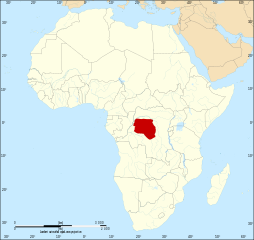
| ref | 18 saneaksat 2011 à 08:51 | | 1525 × 1440 (577 kio) | Alphathon | == {{int:filedesc}} == {{Information |Description={{en|Map of the geographic distribution of bonobo's (''Pan paniscus'') within the African continent.}} Map: Lambert azimutal equal-area projection, WGS84 datum, |
Favera va iyeltak
Valevefa 2 bugluyaxa va bat iyeltak :
Jadifa iyeltakura
Valevefi wiki va bat iyeltak malsaved :
- Favera dene af.wikipedia.org
- Favera dene an.wikipedia.org
- Favera dene ar.wikipedia.org
- Favera dene arz.wikipedia.org
- Favera dene azb.wikipedia.org
- Favera dene bg.wikipedia.org
- Favera dene bs.wikipedia.org
- Favera dene ca.wikipedia.org
- Favera dene cs.wikipedia.org
- Favera dene da.wikipedia.org
- Favera dene diq.wikipedia.org
- Favera dene en.wikipedia.org
- Favera dene en.wikiquote.org
- Favera dene et.wikipedia.org
- Favera dene eu.wikipedia.org
- Favera dene ga.wikipedia.org
- Favera dene gl.wikipedia.org
- Favera dene he.wikipedia.org
- Favera dene hi.wikipedia.org
- Favera dene is.wikipedia.org
- Favera dene it.wikipedia.org
- Favera dene ka.wikipedia.org
- Favera dene ku.wikipedia.org
- Favera dene lt.wikipedia.org
- Favera dene lv.wikipedia.org
- Favera dene nn.wikipedia.org
- Favera dene no.wikipedia.org
- Favera dene os.wikipedia.org
- Favera dene pa.wikipedia.org
- Favera dene pl.wikipedia.org
- Favera dene pnb.wikipedia.org
- Favera dene pt.wikipedia.org
- Favera dene ro.wikipedia.org
- Favera dene ru.wikipedia.org
- Favera dene sco.wikipedia.org
- Favera dene simple.wikipedia.org
- Favera dene sr.wikipedia.org
- Favera dene tl.wikipedia.org
- Favera dene tl.wikiquote.org
- Favera dene tr.wikipedia.org
- Favera dene uk.wikipedia.org
- Favera dene vi.wikipedia.org
- Favera dene www.wikidata.org