Iyeltak:Haiti topographic map-fr.png

Lum ke bata abdiwira : 800 × 598 px. Ar goraks: 320 × 239 px | 640 × 478 px | 1024 × 765 px | 1280 × 956 px | 1739 × 1299 px.
Xantaf iyeltak (1739 × 1299 pixel, iyeltakaldo : 2,21 Mio, MIME ord : image/png)
Pimtara
| Pimtara |
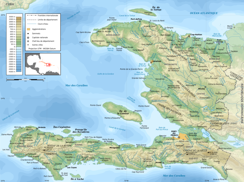
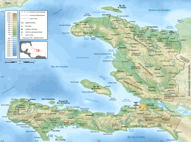
English: Topographic map of Haiti in French. Use the SVG version for translations and alterations, then update this one.
Français : Carte topographique d'Haïti en français. Utiliser la version SVG pour les traductions et les changements, puis mettre à jour celle-ci.
|
| Evla | |
| Klita |
Own work. Sources of data:
|
| Askisik | Rémi Kaupp |
| Autres versions |
[]
|


Sortara :
English: This map has been created by Rémi Kaupp (User:Korrigan) and released under the license(s) stated below. You are free to use it for any purpose as long as you credit me and follow the terms of the license. You may need to credit the sources of data of the map (please check). Example:
Français : Cette carte a été créée par Rémi Kaupp (User:Korrigan) et placée sous la ou les licence(s) ci-dessous. Vous êtes libre de la réutiliser, tant que vous me citez en tant qu'auteur et suivez les instructions de la licence. Certaines sources de données de la carte doivent peut-être être créditées, veuillez vérifier. Exemple :
|
 |
Moi, en tant que détenteur des droits d’auteur sur cette œuvre, je la publie sous les licences suivantes :

|
Permission is granted to copy, distribute and/or modify this document under the terms of the GNU Free Documentation License, Version 1.2 or any later version published by the Free Software Foundation; with no Invariant Sections, no Front-Cover Texts, and no Back-Cover Texts. A copy of the license is included in the section entitled GNU Free Documentation License. |
This file is licensed under the Creative Commons Attribution-Share Alike 4.0 International, 3.0 Unported, 2.5 Generic, 2.0 Generic and 1.0 Generic license.
- Til nuyaf :
- Ta walzilira – ta ksudara va kobara azu walzilira azu deara
- Ta warzafa ponara – Ta zalera va grabom
- Nope valevef kredeem :
- gaara – Va folack govanzilil ise va gluyaxa godaful ise gobazel kase betara al zo skud. Laninde gonaskil voxe mekane gometiavel da gelfasik va rin ik rinafa favera vanovar.
- Milinde paká – Ede va bat valdig betal ike artazukar ike voner, pune va nekis valdig wetce mila ok milafa sorta gu bat goxolel.
Va solnarina sorta rorewal
Iyeltakizvot
Witison va iyeltak inde in banugale awir, va evla/bartiv vulegal !!
| Evla/Bartiv | Aluk | Lumeem | Favesik | Sebuks | |
|---|---|---|---|---|---|
| ref | 11 bareaksat 2009 à 19:26 | | 1739 × 1299 (2,21 Mio) | Korrigan | + masque blanc pour pays étrangers |
| 9 bareaksat 2009 à 22:49 |  | 1739 × 1299 (2,22 Mio) | Korrigan | Recadrage de la carte de situation | |
| 9 bareaksat 2009 à 22:30 |  | 1739 × 1299 (2,22 Mio) | Korrigan | - cadre, + chaînes de montagne, meilleure carte de situation | |
| 7 bareaksat 2009 à 00:37 |  | 1739 × 1299 (2,21 Mio) | Korrigan | == Description == {{Information |Description={{en|Topographic map of Haiti in French}} {{fr|Carte topographique d'Haïti en français.}} * UTM projection, WGS84 datum * The shaded relief is an embedded raster image, delete it to make the file smaller. |
Favera va iyeltak
Valevefa bugluyaxa va bat iyeltak :
Jadifa iyeltakura
Valevefi wiki va bat iyeltak malsaved :
- Favera dene ar.wikipedia.org
- Favera dene ca.wikipedia.org
- Favera dene ceb.wikipedia.org
- Favera dene de.wikipedia.org
- Favera dene en.wikipedia.org
- Favera dene eo.wikipedia.org
- Favera dene es.wikipedia.org
- Favera dene fa.wikipedia.org
- Favera dene fr.wikipedia.org
- Discussion Wikipédia:Atelier graphique/Archive 4
- Géographie d'Haïti
- Artibonite (fleuve)
- Projet:Cartographie/Cartes standards/Pays
- Histoire de la caféiculture
- Wikipédia:Image du jour/mai 2009
- Wikipédia:Image du jour/12 mai 2009
- Massif de la Hotte
- Chaîne de la Selle
- Rivière Soliette
- Chaîne des Matheux
- Massif des Montagnes Noires
- Rivière de Montrouis
- Chaîne du Trou d'Eau
- Massif du Nord
- Rivière des Ténèbres
- Rivière Libon
- Rivière Macassia
- Rivière Fer à Cheval
- Pedernales (rivière)
- Rivière Limbé
- Grande Rivière du Nord
- Rivière Bouyaha
- Liste de catastrophes naturelles en Haïti
- Rivière Guayamouc
- Rivière l'Estère
- Rivière Blanche (département de l'Ouest)
- Rivière Grise
- Rivière de Cavaillon
- Ravine du Sud
- Liste des cours d'eau d'Haïti
- Rivière Torbeck
- Acul du Sud
- Rivière Bainet
- Grande Rivière de Nippes
- Rivière de la Cosse
- Rivière Momance
loa favera va bat iyeltak wil !!