Iyeltak:MapaSociedadesAutóctonasCostaRica.JPG

Lum ke bata abdiwira : 652 × 600 px. Ar goraks: 261 × 240 px | 522 × 480 px | 1000 × 920 px.
Xantaf iyeltak (1000 × 920 pixel, iyeltakaldo : 102 kio, MIME ord : image/jpeg)

|
Cette image (de type carte) devrait être recréée dans un format vectoriel, en tant que fichier SVG. Cela offrirait plusieurs avantages : voir Commons:Media for cleanup pour plus d'informations. Si une version SVG de cette image est déjà disponible, merci de bien vouloir l'envoyer. Après cela, remplacez ce modèle par {{vector version available|nouveau nom d'image.svg}}.
|


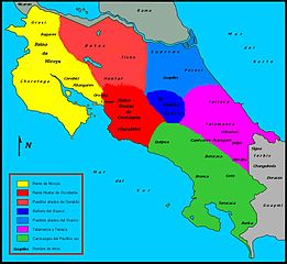
| Pimtara | Mapa de las sociedades autóctonas costarricenses del siglo XVI a la llegada de los españoles (1502), según el mapa elaborado por Mario Porras y Laura Sancho en 1998, publicado en el libro de Ana María Botey Sobrado (2002): Costa Rica: de las sociedades autóctonas hasta 1914, Editorial de la UCR, p.71, ISBN 9977-67-694-1. |
| Evla | (UTC) |
| Klita | |
| Askisik |
|
| Cette image a été retouchée, ce qui signifie qu'elle a été modifiée par ordinateur et est différente de l'image d'origine. Liste des modifications : Se divide el mapa por colores para delimitar las sociedades autóctonas costarricenses del siglo XVI. Se agrega una leyenda por colores. Se agregan los nombres de las respectivas etnias y reinos según el mapa elaborado por Mario Porras y Laura Sancho en 1998, publicado en el libro de Ana María Botey Sobrado (2002): Costa Rica: de las sociedades autóctonas hasta 1914, Editorial de la UCR, p.71, ISBN 9977-67-694-1. Se retiran las leyendas "Costa Rica", "Mar Caribe", "Océano Pacífico" y el mapa de la Isla del Coco, y se substituyen por "Mar del Norte" y "Mar del Sur". Se agrega la rosa náutica marcando el norte. Se guarda el archivo en versión .jpg. Programa utilizado: PaintBrush.. L'image d'origine se trouve ici : Mapa CR.svg:
|
Moi, en tant que détenteur des droits d’auteur sur cette œuvre, je la publie sous les licences suivantes :
Ce fichier est sous licence Creative Commons Attribution – Partage dans les Mêmes Conditions 2.5 Générique, 2.0 Générique et 1.0 Générique.
- Til nuyaf :
- Ta walzilira – ta ksudara va kobara azu walzilira azu deara
- Ta warzafa ponara – Ta zalera va grabom
- Nope valevef kredeem :
- gaara – Va folack govanzilil ise va gluyaxa godaful ise gobazel kase betara al zo skud. Laninde gonaskil voxe mekane gometiavel da gelfasik va rin ik rinafa favera vanovar.
- Milinde paká – Ede va bat valdig betal ike artazukar ike voner, pune va nekis valdig wetce mila ok milafa sorta gu bat goxolel.
| Bat iyeltak wetce Creative Commons Attribution-Share Alike 3.0 Unported zo sortayar. | ||
| ||
| Ce bandeau de licence a été ajouté à ce fichier dans le cadre de la procédure de mise à jour des licences des images sous GFDL. |

|
Permission is granted to copy, distribute and/or modify this document under the terms of the GNU Free Documentation License, Version 1.2 or any later version published by the Free Software Foundation; with no Invariant Sections, no Front-Cover Texts, and no Back-Cover Texts. A copy of the license is included in the section entitled GNU Free Documentation License. |
Va solnarina sorta rorewal
Journal des téléversements d’origine
This image is a derivative work of the following images:
- File:Mapa_CR.svg licensed with Cc-by-sa-2.5,2.0,1.0, Cc-by-sa-3.0-migrated, GFDL
- 2007-07-07T15:58:04Z Shamhain 722x664 (78842 Bytes) {{Information |Description= Mapa de Costa Rica |Source= Trabajo propio |Date= 07-07-2007 |Author= Shamhain |Permission= |other_versions= }}
- 2007-07-07T03:02:53Z Shamhain 722x664 (76503 Bytes) {{Information |Description= mapa del territorio costarricense |Source= Own Work |Date= 07-06-2007 |Author= Shamhain |Permission= |other_versions= }}
- 2007-07-07T01:34:33Z Shamhain 722x664 (79667 Bytes) {{Information |Description= Mapa del territorio Costarricense |Source= Own Work |Date= 07-06-2007 |Author= Shamhain |Permission= |other_versions= }}
- 2007-07-07T01:30:12Z Shamhain 722x664 (79666 Bytes) {{Information |Description= Mapa de Costa Rica |Source= Own Work |Date= 07-06-2007 |Author= Shamhain |Permission= |other_versions= }}
Téléversé avec derivativeFX
Iyeltakizvot
Witison va iyeltak inde in banugale awir, va evla/bartiv vulegal !!
| Evla/Bartiv | Aluk | Lumeem | Favesik | Sebuks | |
|---|---|---|---|---|---|
| ref | 20 lerdeaksat 2011 à 20:21 | | 1000 × 920 (102 kio) | Rodtico21 | {{Information |Description=Mapa de las sociedades autóctonas costarricenses del siglo XVI a la llegada de los españoles (1502), según el mapa elaborado por Mario Porras y Laura Sancho en 1998, publicado en el libro de Ana María Botey Sobrado (2002): ' |
Favera va iyeltak
Valevefa 3 bugluyaxa va bat iyeltak :
Jadifa iyeltakura
Valevefi wiki va bat iyeltak malsaved :
- Favera dene ca.wikipedia.org
- Favera dene cs.wikipedia.org
- Favera dene de.wikipedia.org
- Favera dene es.wikipedia.org
- Favera dene fr.wikipedia.org
- Favera dene lt.wikipedia.org
- Favera dene nl.wikipedia.org
- Favera dene uk.wikipedia.org
- Favera dene www.wikidata.org