Iyeltak:New guinea named.PNG

Lum ke bata abdiwira : 800 × 417 px. Ar goraks: 320 × 167 px | 640 × 333 px | 1024 × 534 px | 1280 × 667 px | 2205 × 1149 px.
Xantaf iyeltak (2205 × 1149 pixel, iyeltakaldo : 86 kio, MIME ord : image/png)

|
Cette image (de type locator map) devrait être recréée dans un format vectoriel, en tant que fichier SVG. Cela offrirait plusieurs avantages : voir Commons:Media for cleanup pour plus d'informations. Si une version SVG de cette image est déjà disponible, merci de bien vouloir l'envoyer. Après cela, remplacez ce modèle par {{vector version available|nouveau nom d'image.svg}}.
|
Pimtara
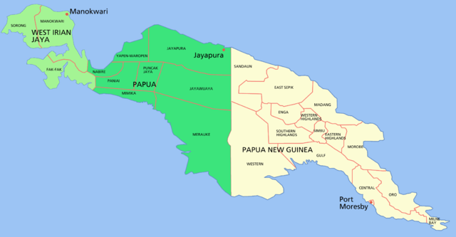
Map of the island of w:New Guinea
- Green = western New Guinea, (Indonesia) divided into the two provinces of West Irian Jaya (light green) and Papua (dark green).
- Beige = eastern New Guinea, the 'mainland' portion of the nation of Papua New Guinea
Shows capital cities and provinces
For a blank map see Image:New guinea blank.PNG
Sortara :

|
Permission is granted to copy, distribute and/or modify this document under the terms of the GNU Free Documentation License, Version 1.2 or any later version published by the Free Software Foundation; with no Invariant Sections, no Front-Cover Texts, and no Back-Cover Texts. A copy of the license is included in the section entitled GNU Free Documentation License. |
| Bat iyeltak wetce Creative Commons Attribution-Share Alike 3.0 Unported zo sortayar. | ||
| ||
| Ce bandeau de licence a été ajouté à ce fichier dans le cadre de la procédure de mise à jour des licences des images sous GFDL. |
Iyeltakizvot
Witison va iyeltak inde in banugale awir, va evla/bartiv vulegal !!
| Evla/Bartiv | Aluk | Lumeem | Favesik | Sebuks | |
|---|---|---|---|---|---|
| ref | 24 toleaksat 2006 à 04:29 | | 2205 × 1149 (86 kio) | Roke~commonswiki | Map of the island of New Guinea Category: New Guinea |
Favera va iyeltak
Meku bu va bata ewava ruldar.
Jadifa iyeltakura
Valevefi wiki va bat iyeltak malsaved :
- Favera dene af.wikipedia.org
- Favera dene als.wikipedia.org
- Favera dene ar.wikipedia.org
- Favera dene ban.wikipedia.org
- Favera dene bat-smg.wikipedia.org
- Favera dene ca.wikipedia.org
- Favera dene cs.wikipedia.org
- Favera dene de.wikipedia.org
- Favera dene de.wikinews.org
- Favera dene el.wikipedia.org
- Favera dene en.wikipedia.org
- Favera dene en.wiktionary.org
- Favera dene es.wikipedia.org
- Favera dene fa.wikipedia.org
- Favera dene fi.wikipedia.org
- Favera dene fr.wikipedia.org
- Favera dene gd.wikipedia.org
- Favera dene gl.wikipedia.org
- Favera dene gn.wikipedia.org
- Favera dene hak.wikipedia.org
- Favera dene he.wikipedia.org
- Favera dene hu.wikipedia.org
- Favera dene id.wikipedia.org
- Favera dene id.wiktionary.org
- Favera dene ja.wikipedia.org
- Favera dene ka.wikipedia.org
loa favera va bat iyeltak wil !!