Iyeltak:Orontid Armenia -250-en.svg

Taille de cet aperçu PNG pour ce fichier SVG : 800 × 470 px. Ar goraks: 320 × 188 px | 640 × 376 px | 1024 × 601 px | 1280 × 751 px | 2560 × 1503 px | 2717 × 1595 px.
Xantaf iyeltak (SVG iyeltak, prekson 2717 × 1595 pixels, iyeltakaldo : 766 kio)
Pimtara
| Pimtara |
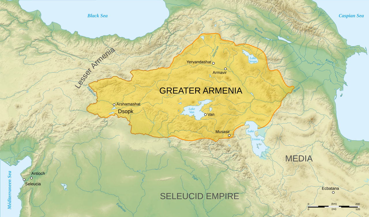
English: Map of Orontid Armenia, around the year 250 BCE.
Français : Carte en anglais de l'Arménie sous la dynastie orontide, vers l'an -250. |
||
| Evla | |||
| Klita |
Own work.
Sources :
Software used :
Autres données :
|
||
| Askisik | Sémhur | ||
| Autres versions |
[]
| ||
| Gaara (imposé par la licence) | © Sémhur / Wikimedia Commons / | ||
| SVG | W3C-validity not checked. Cette image vectorielle non W3C-spécifiée a été créée avec Inkscape .
|
||
| Atelier graphique |


| Lieu de la prise de vue | | Voir cet endroit et d’autres images sur : OpenStreetMap |
|---|
Sortara :
Moi, en tant que détenteur des droits d’auteur sur cette œuvre, je la publie sous les licences suivantes :
| Copyleft : cette œuvre d’art est libre ; vous pouvez la redistribuer ou la modifier selon les termes de la licence Art Libre. Vous trouverez un exemplaire de cette licence sur le site Copyleft Attitude ainsi que sur d’autres sites. |
This file is licensed under the Creative Commons Attribution-Share Alike 4.0 International, 3.0 Unported, 2.5 Generic, 2.0 Generic and 1.0 Generic license.
- Til nuyaf :
- Ta walzilira – ta ksudara va kobara azu walzilira azu deara
- Ta warzafa ponara – Ta zalera va grabom
- Nope valevef kredeem :
- gaara – Va folack govanzilil ise va gluyaxa godaful ise gobazel kase betara al zo skud. Laninde gonaskil voxe mekane gometiavel da gelfasik va rin ik rinafa favera vanovar.
- Milinde paká – Ede va bat valdig betal ike artazukar ike voner, pune va nekis valdig wetce mila ok milafa sorta gu bat goxolel.
Va solnarina sorta rorewal
Iyeltakizvot
Witison va iyeltak inde in banugale awir, va evla/bartiv vulegal !!
| Evla/Bartiv | Aluk | Lumeem | Favesik | Sebuks | |
|---|---|---|---|---|---|
| ref | 12 taneaksat 2008 à 18:47 | | 2717 × 1595 (766 kio) | Sémhur | == Description == {{Information |Description= {{en| Map of Orontid Armenia, around the year -250 AD.}} {{fr| Carte en anglais de l'Arménie sous la dynastie orontide, vers l'an -250.}} |Source=Own work. { |
Favera va iyeltak
Valevefa 6 bugluyaxa va bat iyeltak :
Jadifa iyeltakura
Valevefi wiki va bat iyeltak malsaved :
- Favera dene ar.wikipedia.org
- Favera dene azb.wikipedia.org
- Favera dene en.wikipedia.org
- Favera dene fa.wikipedia.org
- Favera dene hy.wikipedia.org
- Տիգրան Մեծ
- Հայեր
- Տրդատ Գ
- Արտաշեսյաններ
- Երվանդունիներ
- Արշակունիներ
- Վաղարշակ Ա
- Ռուբեն Ա
- Արտավազդ Ա
- Արտավազդ Գ
- Արտավազդ Դ
- Արտավազդ Ե
- Արտավազդ Բ
- Արտաշես Ա Բարեպաշտ
- Արտաշես Դ
- Վռամշապուհ
- Արտաշես Բ
- Արշակ Ա
- Արշակ Գ
- Արշակ Բ
- Պապ թագավոր
- Աշոտ Ա Մեծ
- Աշոտ Գ Ողորմած
- Աշոտ Դ Քաջ
- Գագիկ Բ
- Հովհաննես-Սմբատ
- Հեթում Ա
- Ֆիլիպ (Կիլիկիայի թագավոր)
- Հեթում Բ
- Հեթումյաններ
- Օշին Ա
- Տրդատ Բ
- Տրդատ Ա
- Խոսրով Ա
- Վաղարշ Ա
- Սոհեմոս
- Վաղարշ Բ
- Լևոն Ե
- Լևոն Դ
- Լևոն Ա
- Լևոն Զ
- Լևոն Գ
loa favera va bat iyeltak wil !!