Iyeltak:Panama relief location map.jpg

Lum ke bata abdiwira : 800 × 403 px. Ar goraks: 320 × 161 px | 640 × 322 px | 1024 × 516 px | 1280 × 644 px | 2187 × 1101 px.
Xantaf iyeltak (2187 × 1101 pixel, iyeltakaldo : 899 kio, MIME ord : image/jpeg)
Pimtara
| Pimtara |
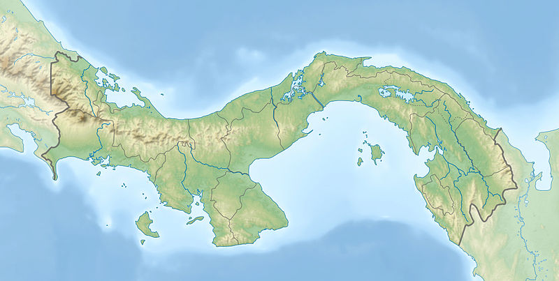
English: Physical location map of Panama
Equirectangular projection. Geographic limits of the map:
Deutsch: Physische Positionskarte von Panama
Quadratische Plattkarte. Geographische Begrenzung der Karte:
|
| Evla | |
| Klita |
Pilkaf grabom
|
| Askisik | Alexrk2 |
| Autres versions |
|


|
Cette carte a été créée ou améliorée dans le Kartenwerkstatt (Atelier cartographique allemand). Vous pouvez également y proposer des cartes à améliorer.
|
Sortara :
Moi, en tant que détenteur des droits d’auteur sur cette œuvre, je la publie sous les licences suivantes :

|
Permission is granted to copy, distribute and/or modify this document under the terms of the GNU Free Documentation License, Version 1.2 or any later version published by the Free Software Foundation; with no Invariant Sections, no Front-Cover Texts, and no Back-Cover Texts. A copy of the license is included in the section entitled GNU Free Documentation License. |
Bat iyeltak wetce Creative Commons Attribution-Share Alike 3.0 Unported zo sortayar.
- Til nuyaf :
- Ta walzilira – ta ksudara va kobara azu walzilira azu deara
- Ta warzafa ponara – Ta zalera va grabom
- Nope valevef kredeem :
- gaara – Va folack govanzilil ise va gluyaxa godaful ise gobazel kase betara al zo skud. Laninde gonaskil voxe mekane gometiavel da gelfasik va rin ik rinafa favera vanovar.
- Milinde paká – Ede va bat valdig betal ike artazukar ike voner, pune va nekis valdig wetce mila ok milafa sorta gu bat goxolel.
Va solnarina sorta rorewal
| Annotations | This image is annotated: View the annotations at Commons |
Iyeltakizvot
Witison va iyeltak inde in banugale awir, va evla/bartiv vulegal !!
| Evla/Bartiv | Aluk | Lumeem | Favesik | Sebuks | |
|---|---|---|---|---|---|
| ref | 1 taneaksat 2014 à 18:04 | | 2187 × 1101 (899 kio) | NordNordWest | + Panama Oeste |
| 22 pereaksat 2009 à 16:21 |  | 2187 × 1101 (785 kio) | Alexrk2 | Enhanced admin borders | |
| 19 pereaksat 2009 à 14:00 |  | 2186 × 1101 (774 kio) | Alexrk2 | changed dim | |
| 19 pereaksat 2009 à 13:53 |  | 2186 × 1101 (772 kio) | Alexrk2 | == Beschreibung == {{Information |Description={{en|1=Physical location map of Panama Equirectangular projection. Geographic limits of the map: * N: 10.28° N * S: 6.79° N * W: 83.56° W * O: 76.64° W}} {{de|1=Physische Positionskarte von |
Favera va iyeltak
Valevefa bugluyaxa va bat iyeltak :
Jadifa iyeltakura
Valevefi wiki va bat iyeltak malsaved :
- Favera dene als.wikipedia.org
- Favera dene ar.wikipedia.org
- Favera dene arz.wikipedia.org
- Favera dene ast.wikipedia.org
- Favera dene az.wikipedia.org
- Favera dene ban.wikipedia.org
- Favera dene ba.wikipedia.org
- Favera dene be-tarask.wikipedia.org
- Favera dene be.wikipedia.org
- Favera dene bg.wikipedia.org
- Favera dene bn.wikipedia.org
- Favera dene bs.wikipedia.org
- Favera dene ca.wikipedia.org
- Favera dene ceb.wikipedia.org
- Favera dene ce.wikipedia.org
- Favera dene ckb.wikipedia.org
- Favera dene cs.wikipedia.org
loa favera va bat iyeltak wil !!