Iyeltak:Sulawesi Locator Topography.png
Lum ke bata abdiwira : 642 × 599 px. Ar goraks: 257 × 240 px | 514 × 480 px | 823 × 768 px | 1097 × 1024 px | 1991 × 1858 px.
Xantaf iyeltak (1991 × 1858 pixel, iyeltakaldo : 1,88 Mio, MIME ord : image/png)
Pimtara
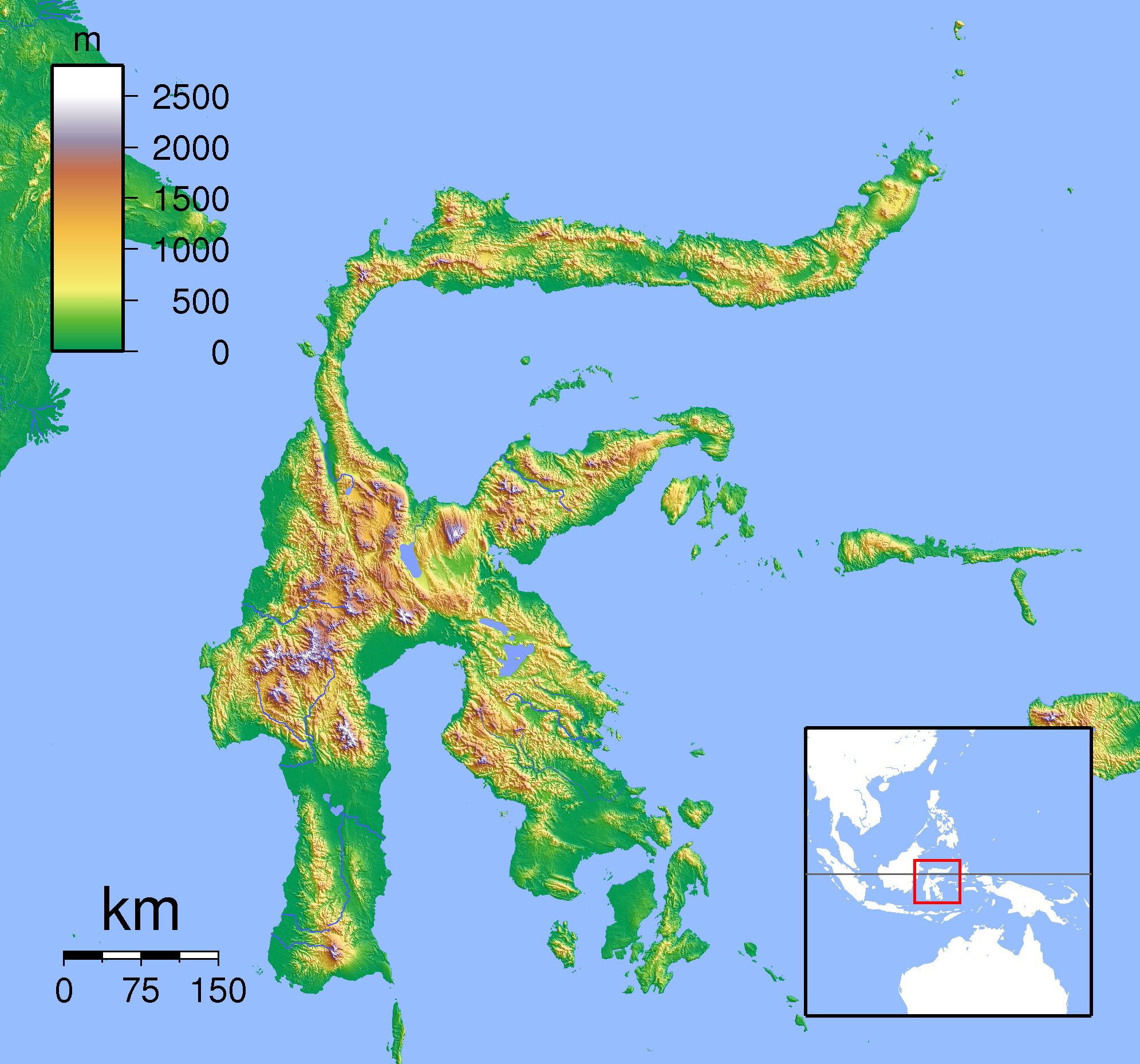
| Pimtara | Topographic location map of Sulawesi. Created with SRTM from publicly released SRTM data. For non-locator version, see Image:Sulawesi Topography.png. Left:117 South:-6.333333 Right:127 Top:3 |
| Evla | |
| Klita | Pilkaf grabom |
| Askisik | Sadalmelik |
Sortara :
Moi, en tant que détenteur des droits d’auteur sur cette œuvre, je la publie sous les licences suivantes :

|
Permission is granted to copy, distribute and/or modify this document under the terms of the GNU Free Documentation License, Version 1.2 or any later version published by the Free Software Foundation; with no Invariant Sections, no Front-Cover Texts, and no Back-Cover Texts. A copy of the license is included in the section entitled GNU Free Documentation License. |
Ce fichier est sous licence Creative Commons Attribution – Partage dans les Mêmes Conditions 3.0 (non transposée), 2.5 Générique, 2.0 Générique et 1.0 Générique.
- Til nuyaf :
- Ta walzilira – ta ksudara va kobara azu walzilira azu deara
- Ta warzafa ponara – Ta zalera va grabom
- Nope valevef kredeem :
- gaara – Va folack govanzilil ise va gluyaxa godaful ise gobazel kase betara al zo skud. Laninde gonaskil voxe mekane gometiavel da gelfasik va rin ik rinafa favera vanovar.
- Milinde paká – Ede va bat valdig betal ike artazukar ike voner, pune va nekis valdig wetce mila ok milafa sorta gu bat goxolel.
Va solnarina sorta rorewal
Iyeltakizvot
Witison va iyeltak inde in banugale awir, va evla/bartiv vulegal !!
| Evla/Bartiv | Aluk | Lumeem | Favesik | Sebuks | |
|---|---|---|---|---|---|
| ref | 22 taneaksat 2011 à 19:19 | | 1991 × 1858 (1,88 Mio) | Beao | Border. |
| 1 lerdeaksat 2007 à 18:17 |  | 2008 × 1871 (1,89 Mio) | Sadalmelik | {{Information |Description=Topographic location map of Sulawesi. Created with SRTM from publicly released SRTM data. For non-locator version, see Image:Sulawesi Topography.png. Left:117 South:-6.333333 Right:127 Top:3 |Source=self-made |Date=Sep 1, 2 |
Favera va iyeltak
Valevefa bugluyaxa va bat iyeltak :
Jadifa iyeltakura
Valevefi wiki va bat iyeltak malsaved :
- Favera dene an.wikipedia.org
- Favera dene ar.wikipedia.org
- Favera dene ban.wikipedia.org
- Favera dene ceb.wikipedia.org
- Favera dene en.wikipedia.org
- Favera dene eo.wikipedia.org
- Favera dene es.wikipedia.org
- Favera dene fa.wikipedia.org
- Favera dene fr.wikipedia.org
- Favera dene gl.wikipedia.org
- Favera dene id.wikipedia.org
- Favera dene it.wikipedia.org
- Favera dene it.wikivoyage.org
- Favera dene ka.wikipedia.org
- Favera dene kn.wikipedia.org
- Favera dene min.wikipedia.org
- Favera dene ms.wikipedia.org
- Favera dene nl.wikipedia.org
- Favera dene pnb.wikipedia.org
- Favera dene pt.wikipedia.org
- Favera dene sco.wikipedia.org
- Favera dene ta.wikipedia.org
- Favera dene th.wikipedia.org
- Favera dene uk.wikipedia.org
- Favera dene ur.wikipedia.org
- Favera dene vi.wikipedia.org
loa favera va bat iyeltak wil !!