Iyeltak:Sulawesi Topography.png

Lum ke bata abdiwira : 649 × 600 px. Ar goraks: 260 × 240 px | 519 × 480 px | 831 × 768 px | 1108 × 1024 px | 2153 × 1990 px.
Xantaf iyeltak (2153 × 1990 pixel, iyeltakaldo : 1,71 Mio, MIME ord : image/png)
Pimtara
| Pimtara |
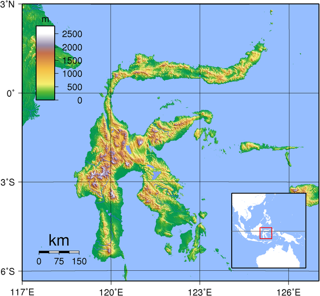
English: Relief (hypsometric) map of Sulawesi. Created with GMT from publicly released SRTM data. For locator version, see Image:Sulawesi_Locator_Topography.png
|
| Evla | |
| Klita | Pilkaf grabom |
| Askisik | Sadalmelik |

|
Cette image a été promue selon les critères des images de valeur, et est considérée comme l’image de plus grande valeur sur Commons dans le domaine : Hypsometric map of Sulawesi. La proposition est consultable sur Commons:Valued image candidates/Sulawesi Topography.png. |
Sortara :
Moi, en tant que détenteur des droits d’auteur sur cette œuvre, je la publie sous les licences suivantes :

|
Permission is granted to copy, distribute and/or modify this document under the terms of the GNU Free Documentation License, Version 1.2 or any later version published by the Free Software Foundation; with no Invariant Sections, no Front-Cover Texts, and no Back-Cover Texts. A copy of the license is included in the section entitled GNU Free Documentation License. |
Ce fichier est sous licence Creative Commons Attribution – Partage dans les Mêmes Conditions 3.0 (non transposée), 2.5 Générique, 2.0 Générique et 1.0 Générique.
- Til nuyaf :
- Ta walzilira – ta ksudara va kobara azu walzilira azu deara
- Ta warzafa ponara – Ta zalera va grabom
- Nope valevef kredeem :
- gaara – Va folack govanzilil ise va gluyaxa godaful ise gobazel kase betara al zo skud. Laninde gonaskil voxe mekane gometiavel da gelfasik va rin ik rinafa favera vanovar.
- Milinde paká – Ede va bat valdig betal ike artazukar ike voner, pune va nekis valdig wetce mila ok milafa sorta gu bat goxolel.
Va solnarina sorta rorewal
Iyeltakizvot
Witison va iyeltak inde in banugale awir, va evla/bartiv vulegal !!
| Evla/Bartiv | Aluk | Lumeem | Favesik | Sebuks | |
|---|---|---|---|---|---|
| ref | 1 lerdeaksat 2007 à 18:11 | | 2153 × 1990 (1,71 Mio) | Sadalmelik | {{Information |Description=Topographic map of Sulawesi. Created with GMT from publicly released SRTM data. For locator version, see Image:Sulawesi_Locator_Topography.png |Source=self-made |Date=Sep 1, 2007 |Author= Sadalmelik }} |
Favera va iyeltak
Meku bu va bata ewava ruldar.
Jadifa iyeltakura
Valevefi wiki va bat iyeltak malsaved :
- Favera dene ace.wikipedia.org
- Favera dene af.wikipedia.org
- Favera dene ast.wikipedia.org
- Favera dene ban.wikipedia.org
- Favera dene ba.wikipedia.org
- Favera dene be-tarask.wikipedia.org
- Favera dene bg.wikipedia.org
- Favera dene bn.wikipedia.org
- Favera dene br.wikipedia.org
- Favera dene ca.wikipedia.org
- Favera dene cs.wikipedia.org
- Favera dene cy.wikipedia.org
- Favera dene de.wikipedia.org
- Favera dene el.wikipedia.org
- Favera dene en.wikipedia.org
- Favera dene en.wikinews.org
- Favera dene en.wikiversity.org
- Favera dene eo.wikipedia.org
- Favera dene es.wikipedia.org
- Favera dene es.wiktionary.org
- Favera dene et.wikipedia.org
- Favera dene eu.wikipedia.org
- Favera dene frr.wikipedia.org
- Favera dene fr.wikipedia.org
- Favera dene fr.wiktionary.org
- Favera dene fy.wikipedia.org
- Favera dene ga.wikipedia.org
- Favera dene gd.wikipedia.org
- Favera dene ha.wikipedia.org
- Favera dene hu.wikipedia.org
- Favera dene id.wikipedia.org
- Favera dene ilo.wikipedia.org
- Favera dene incubator.wikimedia.org
- Favera dene is.wikipedia.org
- Favera dene it.wikipedia.org
- Favera dene ja.wikipedia.org
- Favera dene ka.wikipedia.org
- Favera dene km.wikipedia.org
- Favera dene ko.wikipedia.org
loa favera va bat iyeltak wil !!