Iyeltak:Union of Soviet Socialist Republics (orthographic projection).svg

Taille de cet aperçu PNG pour ce fichier SVG : 541 × 541 px. Ar goraks: 240 × 240 px | 480 × 480 px | 768 × 768 px | 1024 × 1024 px | 2048 × 2048 px.
Xantaf iyeltak (SVG iyeltak, prekson 541 × 541 pixels, iyeltakaldo : 453 kio)
Pimtara
| Pimtara |
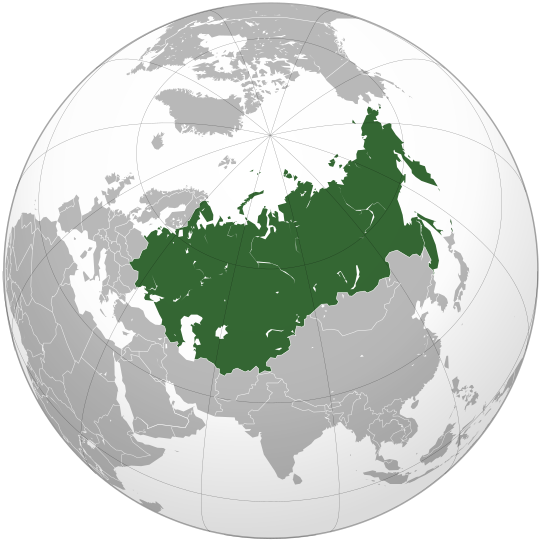
English: The Union of Soviet Socialist Republics (Soviet Union) |
||||
| Evla | |||||
| Klita |
Own work, Cette image vectorielle non W3C-spécifiée a été créée avec Inkscape . Aquarius.geomar.de
|
||||
| Askisik | Ssolbergj | ||||
| Autres versions |
.svg)
|
.svg)
.svg)
.svg)
.svg)
.svg)
.svg)
.svg)
.svg)
.svg)
.svg)
.svg)
.svg)
.svg)
.svg)
.svg)
.svg)
.svg)
.svg)
.svg)
.svg)
.svg)
.svg)
.svg)
.svg)
.svg)
.svg)
.svg)
.svg)
.svg)
.svg)
.svg)
.svg)
.svg)
.svg)
.svg)
.svg)
.svg)
.svg)
.svg)
.svg)
.svg)
.svg)
.svg)
.svg)
.svg)
.svg)
.svg)
.svg)
.svg)
.svg)
.svg)
.svg)
.svg)
.svg)
.svg)
.svg)
.svg)
.svg)
.svg)
.svg)
.svg)
.svg)
.svg)
.svg)
.svg)
.svg)
.svg)
.svg)
.svg)
.svg)
.svg)
.svg)
.svg)

.svg)

.svg)

.svg)
.svg)
.svg)
.svg)
.svg)
.svg)
.svg)


.svg)
.svg)
.svg)
.svg)
.svg)
.svg)
.svg)

.svg)
.svg)
.svg)
.svg)
.svg)
.svg)
.svg)
.svg)
.svg)

.svg)
.svg)
.svg)
.svg)
.svg)
.svg)
.svg)
_without_national_boundaries.svg)
.svg)
.svg)
.svg)
.svg)
.svg)
.svg)

.svg)
.svg)
.png)
.svg)
.svg)
.svg)
.svg)

.svg)
.svg)
.svg)
.svg)
.svg)
.svg)
.svg)
.svg)
.svg)
.svg)
.svg)

.svg)
.svg)
.svg)
.svg)
.svg)
.svg)
.svg)
.svg)
.svg)

.svg)
.svg)

.svg)
.svg)
.svg)
.svg)
.svg)
.svg)
.svg)
.svg)
.svg)
.svg)
.svg)
.svg)
.svg)
.svg)
.svg)
.svg)
.svg)
.svg)
.svg)
.svg)
.svg)
.svg)
.svg)
.svg)
.svg)
.svg)
.svg)
_-_Crimea_disputed.svg)
.svg)
.svg)
.svg)
.svg)
.svg)
.svg)
.svg)
.svg)
.svg)
.svg)
.svg)
_political.svg)
.svg)
.svg)
.svg)
.svg)
_-_Crimea_disputed_-_no_borders.svg)
.svg)
.svg)
.svg)
.svg)
.svg)
.svg)
.svg)
.svg)
.svg)
.svg)
.svg)

.svg)
.svg)
.svg)

.png)
.svg)
.svg)
.svg)
.svg)
.svg)
.svg)
.svg)
.svg)
.svg)
.svg)
.svg)
.svg)
.svg)
.svg)
.svg)
.svg)
.svg)
.svg)
.svg)
.svg)
.svg)
.svg)
.svg)
.svg)
.svg)
.svg)
.svg)
.svg)
.svg)
.svg)
.svg)
.svg)
.svg)
.svg)
.png)
.svg)
.svg)
.svg)
_(orthographic_projection).png)
.svg)
.svg)
.svg)
Sortara :
Moi, en tant que détenteur des droits d’auteur sur cette œuvre, je la publie sous les licences suivantes :
Bat iyeltak wetce Creative Commons Attribution-Share Alike 3.0 Unported zo sortayar.
- Til nuyaf :
- Ta walzilira – ta ksudara va kobara azu walzilira azu deara
- Ta warzafa ponara – Ta zalera va grabom
- Nope valevef kredeem :
- gaara – Va folack govanzilil ise va gluyaxa godaful ise gobazel kase betara al zo skud. Laninde gonaskil voxe mekane gometiavel da gelfasik va rin ik rinafa favera vanovar.
- Milinde paká – Ede va bat valdig betal ike artazukar ike voner, pune va nekis valdig wetce mila ok milafa sorta gu bat goxolel.

|
Permission is granted to copy, distribute and/or modify this document under the terms of the GNU Free Documentation License, Version 1.2 or any later version published by the Free Software Foundation; with no Invariant Sections, no Front-Cover Texts, and no Back-Cover Texts. A copy of the license is included in the section entitled GNU Free Documentation License. |
Va solnarina sorta rorewal
Iyeltakizvot
Witison va iyeltak inde in banugale awir, va evla/bartiv vulegal !!
| Evla/Bartiv | Aluk | Lumeem | Favesik | Sebuks | |
|---|---|---|---|---|---|
| ref | 7 santoleaksat 2021 à 13:52 | | 541 × 541 (453 kio) | Kappasi | Removed nonexistent lake in the Amur. |
| 30 bareaksat 2009 à 01:56 |  | 541 × 541 (521 kio) | Ssolbergj | {{Information |Description={{en|1=The Union of Soviet Socialist Republics (Soviet Union)}} |Source=Own work, {{Inkscape}}<br />[http://www.aquarius.geomar.de/omc/make_map.html Aquarius.geomar.de]<br />{{GFDL-GMT}} |Author=Ssolbergj |Dat |
Favera va iyeltak
Valevefa bugluyaxa va bat iyeltak :
Jadifa iyeltakura
Valevefi wiki va bat iyeltak malsaved :
- Favera dene af.wikipedia.org
- Favera dene af.wiktionary.org
- Favera dene als.wikipedia.org
- Favera dene am.wikipedia.org
- Favera dene ang.wikipedia.org
- Favera dene ar.wikipedia.org
- Favera dene ar.wiktionary.org
- Favera dene ast.wiktionary.org
- Favera dene as.wikipedia.org
- Favera dene av.wikipedia.org
- Favera dene azb.wikipedia.org
- Favera dene az.wiktionary.org
- Favera dene ban.wikipedia.org
- Favera dene ba.wikipedia.org
- Favera dene be-tarask.wikipedia.org
- Favera dene be.wikipedia.org
- Favera dene bg.wikipedia.org
- Favera dene bh.wikipedia.org
- Favera dene bn.wikipedia.org
- Favera dene bo.wikipedia.org
- Favera dene bs.wikipedia.org
- Favera dene bxr.wikipedia.org
- Favera dene cdo.wikipedia.org
- Favera dene ceb.wikipedia.org
- Favera dene ce.wikipedia.org
- Favera dene ckb.wikipedia.org
- Favera dene cs.wikipedia.org
- Favera dene cs.wikiquote.org
- Favera dene cu.wikipedia.org
- Favera dene de.wikipedia.org
- Favera dene de.wikibooks.org
- Favera dene de.wiktionary.org
- Favera dene dsb.wikipedia.org
- Favera dene el.wikipedia.org
loa favera va bat iyeltak wil !!
.svg)
.svg)