Iyeltak:Urartu 610 585-en.svg

Taille de cet aperçu PNG pour ce fichier SVG : 800 × 513 px. Ar goraks: 320 × 205 px | 640 × 410 px | 1024 × 657 px | 1280 × 821 px | 2560 × 1641 px | 2714 × 1740 px.
Xantaf iyeltak (SVG iyeltak, prekson 2714 × 1740 pixels, iyeltakaldo : 855 kio)
Pimtara
| Pimtara |
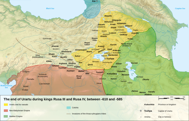
English: Map of the last years of the kingdom of Urartu, between -610 and -585.
Français : Carte en anglais des dernières années du royaume d'Urartu, entre -610 et -585. |
| Evla | |
| Klita |
Own work.
Sources :
Software used :
Other data :
|
| Askisik | Sémhur |
| Autres versions |
See Urartu.
|
| SVG information | Cette carte SVG utilise du texte encapsulé qui peut être traduit facilement à l'aide d'un éditeur de texte. |
| Gaara (imposé par la licence) | © Sémhur / Wikimedia Commons / |

| Lieu de la prise de vue | | Voir cet endroit et d’autres images sur : OpenStreetMap |
|---|
Sortara :
Moi, en tant que détenteur des droits d’auteur sur cette œuvre, je la publie sous les licences suivantes :
| Copyleft : cette œuvre d’art est libre ; vous pouvez la redistribuer ou la modifier selon les termes de la licence Art Libre. Vous trouverez un exemplaire de cette licence sur le site Copyleft Attitude ainsi que sur d’autres sites. |
This file is licensed under the Creative Commons Attribution-Share Alike 4.0 International, 3.0 Unported, 2.5 Generic, 2.0 Generic and 1.0 Generic license.
- Til nuyaf :
- Ta walzilira – ta ksudara va kobara azu walzilira azu deara
- Ta warzafa ponara – Ta zalera va grabom
- Nope valevef kredeem :
- gaara – Va folack govanzilil ise va gluyaxa godaful ise gobazel kase betara al zo skud. Laninde gonaskil voxe mekane gometiavel da gelfasik va rin ik rinafa favera vanovar.
- Milinde paká – Ede va bat valdig betal ike artazukar ike voner, pune va nekis valdig wetce mila ok milafa sorta gu bat goxolel.
Va solnarina sorta rorewal
Iyeltakizvot
Witison va iyeltak inde in banugale awir, va evla/bartiv vulegal !!
| Evla/Bartiv | Aluk | Lumeem | Favesik | Sebuks | |
|---|---|---|---|---|---|
| ref | 10 taneaksat 2008 à 16:18 | | 2714 × 1740 (855 kio) | Sémhur | == Description == {{Information |Description= {{en| Map of the last years of the kingdom of Urartu, between -610 and -585.}} {{fr| Carte en anglais des dernières années du royaume d'Urartu, entre -610 et -585.}} |Source=Own work. {{clr}} Sources : * Top |
Favera va iyeltak
Jadifa iyeltakura
Valevefi wiki va bat iyeltak malsaved :
- Favera dene af.wikipedia.org
- Favera dene de.wikipedia.org
- Favera dene en.wikipedia.org
- Favera dene hr.wikipedia.org
- Favera dene hy.wikipedia.org
- Favera dene it.wikipedia.org
- Favera dene ja.wikipedia.org
- Favera dene ko.wikipedia.org
- Favera dene nl.wikipedia.org
- Favera dene sh.wikipedia.org
- Favera dene simple.wikipedia.org