Meroe
|
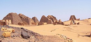
Rawopaf debakeem ke Meroe ewala ( englavon Archaeological Sites of the Island of Meroe ), tir burkaf debak ke Sudana. Meroe tir tano katcalapafo izvaxo ke tawava nume bak 2011 wetce arayaf debak ke tamavafa gadakiewega ke UNESCO zo bendeyer.
Rawopaf debakeem ke Meroe ewala, i lion letaf patectoy wale Nil bost is Atbara kuksa, tiyir idja ke Kush gazaxo gijarotipafo wali vol-VIII-eafa decemda isu vol-IV-eafa. Kiewega vas gazawid ke Kush gazik ke Meroe poke Nil bost is Naqa vegungaf alkaf debak isu Musawwarat es Sufra ruldar. Tiyir kelu ke yon nafalik kereleyes va Misra remi mon tanoya decemda, vanmiae aryona stabrega isu relida isu dopewa isu irubaxo is dere lavagatceso inkexopo. Sinafo gazaxopo divlizeyeno male Mediterranea bira kale idja ke Afrika, isen kiewega va moortera ke yambind is vegeduropa is alkeem is aveem wal bata toloya gola vrutar. ~ UNESCO : Meroe (en) The Archaeological Sites of the Island of Meroe, a semi-desert landscape between the Nile and Atbara rivers, was the heartland of the Kingdom of Kush, a major power from the 8th century B.C. to the 4th century A.D. The property consists of the royal city of the Kushite kings at Meroe, near the River Nile, the nearby religious site of Naqa and Musawwarat es Sufra. It was the seat of the rulers who occupied Egypt for close to a century and features, among other vestiges, pyramids, temples and domestic buildings as well as major installations connected to water management. Their vast empire extended from the Mediterranean to the heart of Africa, and the property testifies to the exchange between the art, architectures, religions and languages of both regions. ~ UNESCO website, licence CC-BY-SA IGO 3.0
Ewava va debak betara
Vuestexa betara
|
| ||||||||||||||||||||||||||||||||||||||||


